
ملف:Nasa AIRS CO2 July03.jpg
حجم هذه المعاينة: 800 × 595 بكسل. الأبعاد الأخرى: 320 × 238 بكسل | 640 × 476 بكسل | 950 × 706 بكسل.
الملف الأصلي (950 × 706 بكسل حجم الملف: 505 كيلوبايت، نوع MIME: image/jpeg)
ملخص
| الوصف |
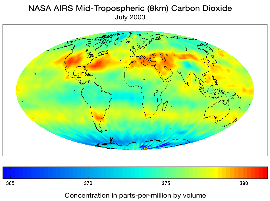
English: Although originally designed to measure atmospheric water vapor and temperature for weather forecasting, scientists working with the Atmospheric Infrared Sounder (AIRS) instrument on the NASA Aqua Spacecraft are now using AIRS to observe atmospheric carbon dioxide. Scientists from NASA, NOAA, ECMWF, UMBC, Princeton and CalTech using several different methods are measuring the concentration of carbon dioxide in the mid-troposphere (about 8 km above the surface). The global map of carbon dioxide above, produced by AIRS Team Leader Dr. Moustafa Chahine at JPL, shows that despite the high degree of mixing that occurs with carbon dioxide, the regional distribution can still be seen by the time the gases reach the mid troposphere. Climate modelers are currently using the AIRS data to understand the global distribution and transport of carbon dioxide and improve their models.
Português: Embora tenha sido originalmente criado para medir o vapor de água na atmosfera e temperatura para previsão do tempo, cientistas trabalharam com o Sondador Infravermelho Atmosférico (em inglês:Atmospheric Infrared Sounder - AIRS), para observar o Dióxido de Carbono atmosférico. Cientistas da NASA, NOAA, ECMWF, UMBC, Princeton e CalTech, utilizando diversos métodos estão medindo a concentração de Dióxido de Carbono na meia-Troposfera (cerca de 8km acima da superfície). O mapa global de dióxido de carbono em questão foi produzido pelo líder de equipe do AIRS no JPL (Jet Propulsion Lab) o Dr. Moustafa Chahine, mostra que apesar do alto grau de mistura que ocorre com o Dióxido de Carbono, a distribuição regional ainda pode ser notada quando os gases alcançam a meia-troposfera. Climatólogos atualmente usam os dados fornecidos pelo AIRS para entender a distribuição global e transporte do Dióxido de Carbono |
| التاريخ | |
| المصدر | English: NASA Goddard Space Flight Center — Aqua Project Science: Global Map of Carbon Dioxide from Space |
| المؤلف |
English: "Image and text courtesy of the AIRS Science Team, JPL."
Português: "Imagem e texto são cortesia do Time de Ciência AIRS, JPL |
| إصدارات أخرى |
ترخيص
| يقع هذا العمل في النِّطاق العامّ في الولايات المُتحدة الأمريكيَّة لأَنَّه عملٌ خالِصٌ من إِنتاج وكالة الفضاء الأمريكيَّة. تنصُ حقوق التَّأليف والنَّشر الخاصَّة بوكالة الفضاء الأمريكيَّة على أنَّ "أعمال الوكالة غير مَحميَّة بحقوق التَّأليف والنَّشر ما لم يُذكر خلافُ ذلك". لمزيدٍ من المعلومات انظر القالِب {{PD-USGov}} وصفحة حقوق التَّأليف والنَّشر الخاصَّة بالوكالة وصفحة سياسة الصُّور الخاصَّة بمُختبر الدَّفع النَّفَّاث. | ||
 |
تنبيهات:
|
تاريخ الملف
اضغط على زمن/تاريخ لرؤية الملف كما بدا في هذا الزمن.
| زمن/تاريخ | صورة مصغرة | الأبعاد | مستخدم | تعليق | |
|---|---|---|---|---|---|
| حالي | 23:50، 13 أكتوبر 2007 | | 950 × 706 (505 كيلوبايت) | Delemon | {{Information |Description={{en|Although originally designed to measure atmospheric water vapor and temperature for weather forecasting, scientists working with the Atmospheric Infrared Sounder (AIRS) instrument on the NASA Aqua Spacecraft are now using A |
استخدام الملف
لا توجد صفحات تستخدم هذا الملف.
الاستخدام العالمي للملف
الويكيات الأخرى التالية تستخدم هذا الملف:
- الاستخدام في ar.wikibooks.org
- الاستخدام في ca.wikipedia.org
- الاستخدام في de.wikiversity.org
- الاستخدام في en.wikipedia.org
- الاستخدام في pt.wikipedia.org
- الاستخدام في ru.wikipedia.org